Users can view various information based on translated open-source data (about disaster safety, sightseeing spots, historic places, Michi no Eki roadside stations, etc.) on Google Maps.
Click the circled numbers on the Google Maps view to see pictures and information on each place. For now, we have added 40 locations in South Fukui Prefecture (No.71-100), out of the hundred places featured in the 100 Hometown Views of Fukui. Produced by:Expressions Co., Ltd.
この[福井ふるさと百景(英語版)]は以下の著作物を改変して利用しています。 [福井ふるさと百景]、福井県、クリエ イティブ・コモンズ・ライセンス表示 4.0 国際(https://creativecommons.org/licenses/by/4.0/deed.ja)
おススメの場所を、いくつか以下に抜粋しましたので行楽の参考になれば幸いです。↓
We hope that the excerpts below, showing off some of our recommendations for destinations in Fukui, will help make your next visit more enjoyable.↓
South-① (No.71)
Kotone Tunnel
小刀根トンネル
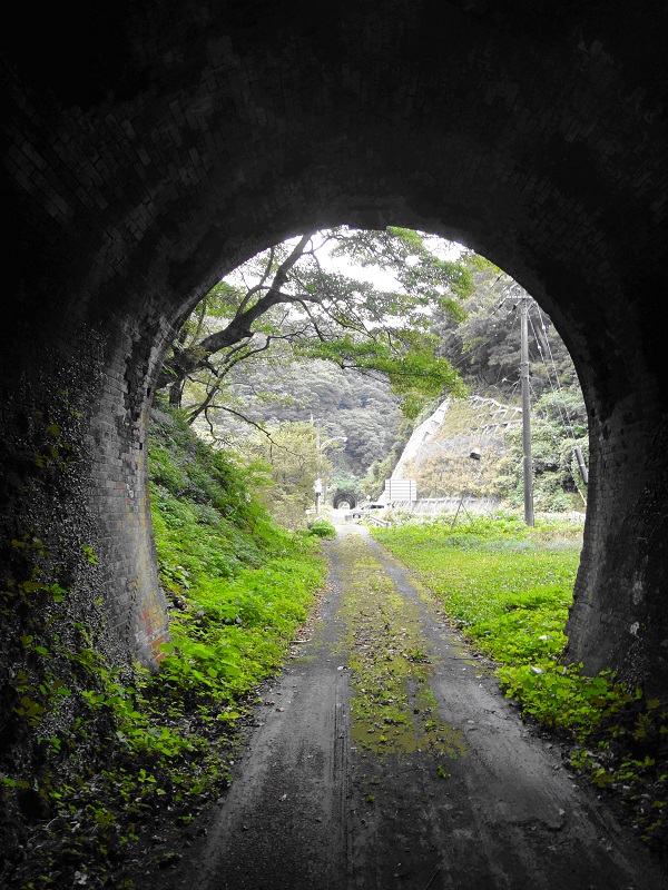
From Tsuruga City to Minami Echizen-cho, vestiges of the rail lines that supported the prefecture’s growth and development dot the landscape. In Tsuruga City’s Tone area, the Kotone Tunnel, through which the former Hokuriku Main Line ran until 1964, still stands today, its keystone bearing the year of its construction, 1881.
敦賀市から南越前町にかけては、福井の発展を支えた近現代の数多くの鉄道景観を見ることができます。敦賀市刀根の集落付近には、旧北陸本線(昭和39年廃止)の路線が通っていた小刀根トンネルが往時を偲ばせる姿で残されており、トンネル上部には「明治14年」と刻まれた要石が現在も残っています。
South-② (No.72)
Vantage point at the Suizu Parking Area
杉津パーキングエリアからの眺望
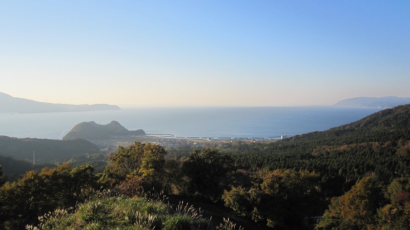
The current Suidsu Parking Area sits atop the remains of the old Suidsu Station, along the Hokuriku Line’s former main line.
Now, the Suidsu Parking Area retains that same entrancing panorama, allowing travelers and passers-by to watch the sun set over the Sea of Japan, slowly disappearing across Tsuruga Bay.
杉津パーキングエリアは、北陸本線旧線(昭和37年廃線)の杉津駅の跡地に建設されました。杉津パーキングエリアからは、素晴らしい景観を見ることができます。
South-⑥ (No.76)
Kehi-jingu Shrine’s grand torii gate
氣比(けひ)神宮の大鳥居
.jpg)
Kehi Shrine’s grand torii gate is among the three largest wooden shrine gates in Japan. Standing at 11m tall, this impressive structure is a beloved symbol of the city.
日本三大木造大鳥居の一つとされる高さ11mの大鳥居は、まさに敦賀のシンボルにふさわしい堂々たる姿。
South-⑧ (No.78)
Kehi no Matsubara Beach
気比の松原
.jpg)
The view created by its white sands and 17,000 pine trees in the space of 400,000 square meters have earned it national recognition as a place of scenic beauty.
気比(けひ)の松原は、40万㎡の広さの中に 17,000本の松が生い茂る国の名勝地です。
South-⑨ (No.79)
Mizushima
水島
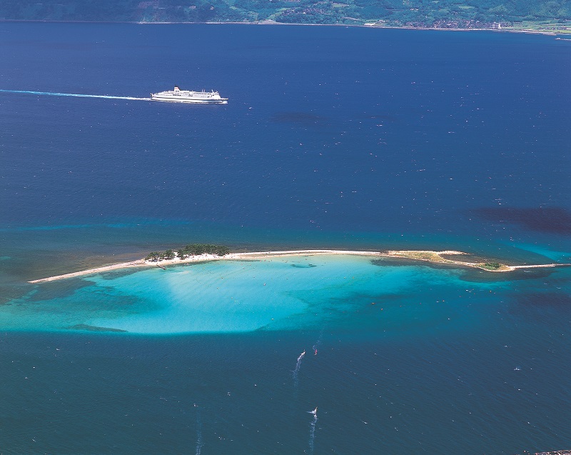
Muzushima, an island comprised of two smaller sand islands, also called “Hawaii of Hokuriku”, floats in Tsuruga Bay near the pristine beaces of Iro ga Hama. The clear blue waters of the ocean cresting over the shore bring to life the very views that captivated poets Saigyō and Bashō, whose works rhapsodized about their allure.
敦賀湾に面し透き通った波に洗われる色ヶ浜の近くには、砂の小島2つからなる水島が浮かび、別名「北陸のハワイ」とも呼ばれています。目の前に広がる色ヶ浜の穏やかな海の表情からは、西行・芭蕉の受けた感動を味わうことができます。
South-⑫ (No.82)
Five Lakes of Mikata
三方五湖
を望む.jpg)
The natural beauty of the Five Lakes of Mikata is representative of the Wakasa Bay National Park, and has enjoyed the highest of reputations from the days of the Manyōshū to the present.
雄大な自然が創り出した若狭の水郷「三方五湖」は、若狭湾国定公園を代表する景勝地であり、万葉集にも歌われているなど古の時代から広く知られた、四季折々の美しさを持つ優雅な湖です。
South-⑬ (No.83)
Performance of the Ō-no-mai at Mimi-jinja Shrine
王の舞の奉納(弥美神社)
.jpg)
Every May brings a performance of the Ō-no-mai, a traditional dance which is performed at Mimi-jinja Shrine, at the western foot of Mt. Mitakesan in the east of Mihama-cho’s Miyashiro district.
雄美浜町宮代地区の東、御岳山の西山麓に位置する弥美(みみ)神社では、毎年5月1日の祭礼において、王の舞が奉納されます。
South-⑯ (No.86)
Water flowing along Uriwari Waterfall
瓜割の滝の荘厳な流れ
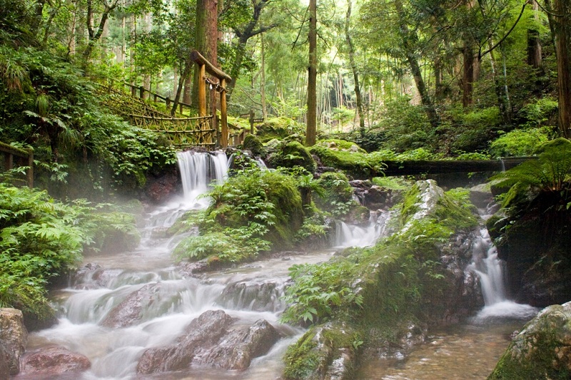
Uriwari Waterfall, whose waters originate in a gorge within the bounds of Wakasa-cho’s Tentoku-ji, derives its name from the clean, clear waters that comprise its flow. Throughout the year its temperature changes little, always cold enough to split melons placed in its waters, hence its name
若狭町の天徳寺境内奥に位置する「瓜割の滝」は、山あいの岩間から湧き出る清泉で、一年を通して水温が変わらず、水につけておいた瓜が割れるほど冷たいことから、その名前がつけられました。
South-⑱ (No.88)
Sotomo Arch
蘇洞門
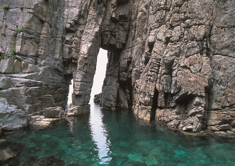
Obama City faces the open ocean from Wakasa Bay and the inland sea of Obama Bay. Nearby Uchitomi Peninsula stretches 6km into Wakasa Bay, and is home to a rare rias coastline which includes the caves and monumental rock formations of Sotomo Arch.
小浜市は、外海の若狭湾と内海の小浜湾に面しています。外海の若狭湾は日本海側では珍しいリアス式海岸で、たいへん波が強く、沖の内外海(うちとみ)半島の先端には、永い年月をかけて波によって削られた「蘇洞門(そとも)」と呼ばれる6kmにわたる壮大な奇岩・洞窟などが見られます。
South-㉑ (No.91)
Myorakuji Temple’s statue of the thousand-armed Kannon
妙楽寺の千手観音立像
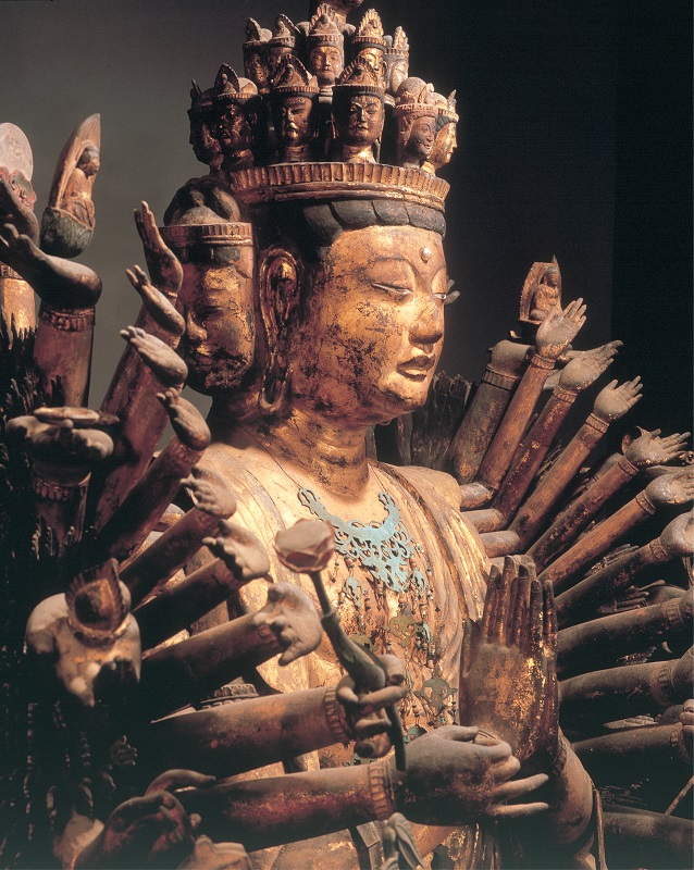
Hagaji Temple’s 11-faced standing statue of Kannon (a National Important Cultural Property), and Myorakuji Temple’s statue of the thousand-armed Kannon are some of the many temples and Buddhist statues that convey to us the history of Buddhism.
重要文化財となっている羽賀寺の十一面観音立像や妙楽寺の千手観音立像など、仏教の歴史の重みを感じさせる貴重な寺や仏像を見ることができます。
South-㉓ (No.93)
Super ogase
スーパー大火勢
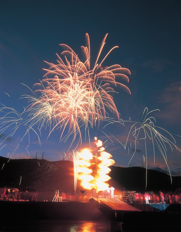
In late August every year, the waters of the Aoto Inlet and Ōshima Peninsula in Ōi-cho are aglow with the brilliant display that is the Wakasa Ōi Super Ōgase fireworks festival. This 300-plus year-old festival has been designated a Prefectural Intangible Folk Cultural Property.
おおい町の大島半島と陸の間の青戸入江の湾内で毎年8月上旬に開催される「若狭おおいのスーパー大火勢(おおがせ)」は、真夏の夜に行われる勇壮・豪快な火祭りで、300年余りの伝統を持つ福谷の大火勢は県無形民俗文化財に指定されています。
South-㉗ (No.97)
Meikyodo
明鏡洞
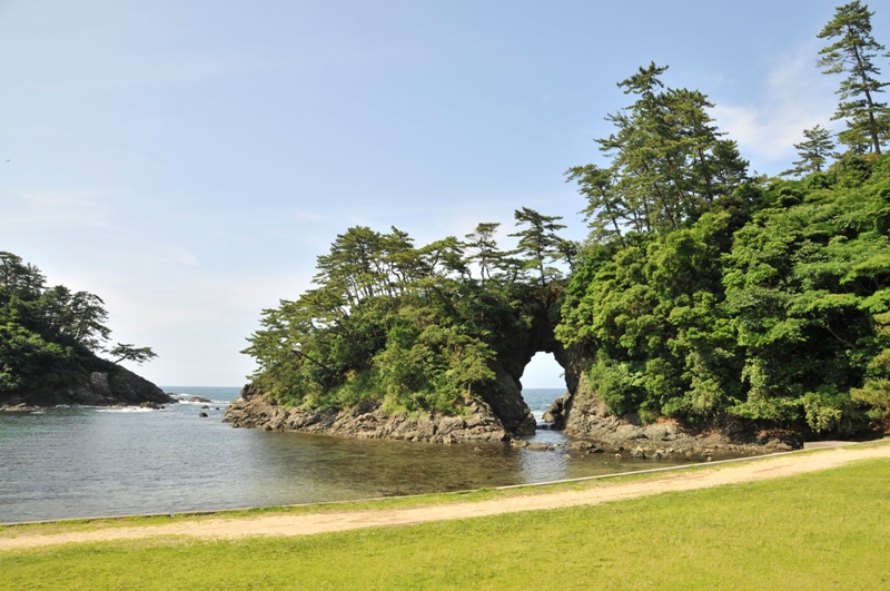
Standing where Takahama Castle looked out over the ocean during the Muromachi Period, Shiroyama Park has been recognized for the beauty of its eight caves (thus gaining the name Yana no Kishō, or “Beautiful Spot of Eight Caves”). Most prominent among them is Meikyōdō, through which observers can enjoy a view of the ocean horizon,
室町時代に築城された高浜城の跡地である城山公園には、長い年月をかけて日本海の荒波がつくりあげた「八穴(やな)の奇勝」と呼ばれる八つの大きな洞穴があり、特にその一穴である「明鏡洞(めいきょうどう)」では、穴の彼方に見える水平線が美しく感じられます。
South-㉙ (No.99)
Hibiki’s terraced rice fields
日引の棚田の田植風景
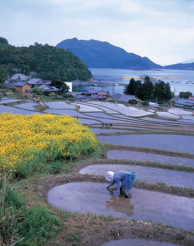
Uchiura Bay, an ocean inlet on the border between Fukui and Kyoto Prefecture, is dotted with cliffs slowly carved by ocean waves over countless years, including the 260m-tall Otomi Cliff. On the eastern-facing slope of the coastline are Hibiki’s terraced rice fields, selected as one of the best 100 terraced rice fields in Japan.
内浦湾は、福井県と京都府の県境にある内湾です。外海に面した側には海蝕崖(かいしょくがい)が発達し、中でも「音海(おとみ)断崖」は海面からの高さが260m以上にも達する日本海側でも有数の断崖地形になっています。湾岸の東向き斜面には「日本の棚田百選」に認定されている「日引(ひびき)の棚田」があり、のどかな農村風景が見られます。
------------------------------------------------------------------
福井観光の隠れた名所が盛りだくさん!
福井ふるさと百景の完全版(No.1-100)は、こちらの 福井県の翻訳・通訳・インバウンド・観光情報発信サイト「福井コラム」 からご確認ください。
For a list of all 100 Scenic Spots in Fukui,
visit our Fukui Column, where we collect information on translation, interpretation, and tourism related to Fukui.
| 福井県の観光マップ、地域情報、伝統芸能、企業紹介などの 翻訳も、ご依頼いただく事ができます。 福井県の翻訳 に関するお問い合わせおよびご相談は、 (株)エクスプレッションズ TEL.076-220-6444まで email: biz@expressions.co.jp |